|
|
|
The Genealogical Research Division of
|
|
|
|
|
|
|
|
The Genealogical Research Division of
|
|

Find a ClassPlease note:
Click on the course titles below to view the course details.
Basic 2: Search Strategies Using Google On Demand / VAS Eligible Learn: how to use google operators, keywords, and keyboard shortcuts. VAS Discount Coupon: Send your receipt to Education@jewishgen.org to receive directions.
Basic 3: Organizing Your Genealogical Research On Demand / VAS Eligible Learn: how to organize your research A-Z, Create files and folders, using forms, and charts. VAS Discount Coupon: Send your receipt to Education@jewishgen.org to receive directions.
On Demand / VAS Eligible Learn: how to organize data, locate and analyze US census and vital, and immigration records. VAS Discount Coupon: Send your receipt to Education@jewishgen.org to receive directions.
US Research Reference Guide II On Demand / VAS Eligible Learn: how to find, identify, and use death, burial, immigration, naturalizations, court records, and military records. VAS Discount Coupon: Send your receipt to Education@jewishgen.org to receive directions.
Jewish in Jewish Genealogy (The Jewish Immigrant Experience in U.S.) On Demand / VAS Eligible Learn: how to understand the Jewish experience, and to apply Jewish filters to your search. VAS Discount Coupon: Send your receipt to Education@jewishgen.org to receive directions.
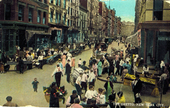
On Demand / VAS Eligible Learn: how to locate and access records, including lesser known sources, in Jewish New York City 1840-1950. VAS Discount Coupon: Send your receipt to Education@jewishgen.org to receive directions.
Publishing & Packaging your Genealogical Research On Demand / VAS Eligible Learn: how to create a step-by-step process to write your narrative, and publishing venues. VAS Discount Coupon: Send your receipt to Education@jewishgen.org to receive directions.
January 5-26, 2025 Instructor: Nancy Holden Learn: how to organize and focus a search, build and fill a family tree chart, locate and analyze census, immigration, and vital records.
Fundamentals II: Plan for Success February 2-23, 2025 Instructor: Margie Geiser Learn: how to plan your research, create a research goal, and name appropriate sources for records. Prepare a research log.
Research Your Roots Using JewishGen March 2-23, 2025 Instructor: Barbara Rice Learn: how to navigate JewishGen's website and databases.
Independent Study: Create Your Own Project June 1-21, 2025 Instructor: Nancy Holden Learn: how to create a research plan for your project. Set appropriate goals. Create and use a log of resources and databases.
March 9-30, 2025 Instructor: Nancy Holden Learn: how to overcome hurdles using proven strategies, identify relevant records, extract details from found records.
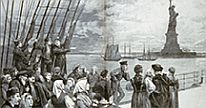
July 6-26, 2025 Instructor: Barbara Rice Learn: how to map your family's voyage from their shtetl to the port of departure. the details of shipping companies, agents, ticket purchase, papers, illegal crossings, bribes, and medical exams.
Sharing Your Stories - Writing Short Narratives January 12 - February 9, 2025 Instructor: Marion Werle Learn: how to write a report of limited scope within a short timeframe, hone your writing skills and showcase your research abilities.
Crafting Stories from Your Family's History March 23, 30 and April 6, 27, 2025 Instructor: Barbara Krasner Learn: to develop your unique writer's voice by writing in class to specific instructor-provided prompts. To encourage confidence, there is volunteer sharing in class without critique.
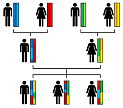
DNA I: Introduction to Genetic Genealogy Jan 30 - Feb 10, 2025 Instructor: Larry Fagan Learn: about the topic of genetic genealogy, the types of available tests and how to build a condensed family tree to optimize your testing strategy.
DNA II: Analyzing your Genetic Genealogy Results July 31 - August 25, 2025 Instructor: Larry Fagan Learn: how to analyze the test results you received. use tools, such as Leeds Analysis, Chromosome Browsers, and DNA Painter to analyze your results.
April 25 - May 18, 2025 Instructor: Lisa Ezrol Curran Learn: About Jewish life in New York City 1840-1950. How to locate and access New York records; including lesser-known sources.
May 4-25, 2025 Instructor: Barbara Rice Learn: how to locate sources using major databases online - Gesher Galicia, JRI-Poland, JewishGen, Roots to Routes, FamilySearch, Polish Archives.
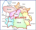
August 17 - September 21, 2025 Instructor: Nancy Holden Learn: how to locate records that exist for your town using - JewishGen, Litvak SIG, Belarus RD, Roots to Routes, FamilySearch. Request records from archives.
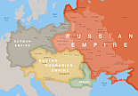
By Request Instructor: April Stone Learn: how to research records from modern countries within Old Hungary, and the major online databases and offline resources.
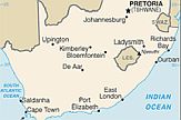
By Request Instructor: Susan Rand-Lakritz Learn: major online databases for South African records, what records exist, and how to organize and track your research.
By Request Instructor: Susan Rand-Lakritz Learn: major online databases for UK records, what records exist, and how to organize and track your research.
Regional Guided Research - a Virtual Conversation On Demand Instructor: Regional Expert Learn: where to start, which databases to use, how to find hidden resources and practical ways to move forward.
Find a Record - a Virtual Conversation On Demand Instructor: Record Specific Learn: depending on request, an expert familiar with specific record sets, finding aids, and filters will be assigned.
Plan Your Research - a Virtual Conversation On Demand Instructor: Margie Geiser Learn: to create a research plan, focus your objectives, plan your research, and use primary record collections.
Individualized Private Mentoring Request your own schedule Instructor: Nancy Holden Learn: how to set up a project, ask for specifics, work at your own pace, obtain new levels of success.
Individualized Private Mentoring Request your own schedule Instructor: Nancy Holden Learn: how to set up a project, ask for specifics, work at your own pace, obtain new levels of success.
Create Your Family History Book - Hire Us By Request Instructor: April Stone – Designer Skills we provide: With your Ancestry.com tree, the JewishGen instructor will design a Family History Book personalized to your unique family history for you to publish and purchase through MyCanvas.
Map It! - Using Historical Maps for Family Research March 2, 9, 16, 2025 Instructor: Hap Ponedel Learn: to use maps for family history using "An Atlas of the Shtetl-Topographic Maps of Eastern Europe"
Feb 2-23, 2025 Instructor: Amy Mitchell Learn: to streamline your work with smart folder systems, research management, and cloud tools, to make documenting your family history easier and more enjoyable Website design by Alan Raskin |
||||||||||||||||
|
|
Edmond J. Safra Plaza | 36 Battery Place | 646.494.2972 | info@jewishgen.org | |
|