|
JCR-UK is a genealogical
and historical website covering all Jewish communities and
congregations
throughout the British Isles and Gibraltar, both past and present.
Town of Tonypandy
Tonypandy is a small town (population of about 4,000), situated on the Rhondda Fawr Valley in South Wales.
It lies about 23 miles north-west of Cardiff,
some 6 miles to the west of Pontypridd.
Penygraig is a village just to the south of Tonypandy.
From 1894,
Tonypandy (including Penygraig) was in the urban district of Ystradyfodwg in the county of
Glamorganshire. In 1897, the district was renamed the urban district of Rhondda
(becoming a
municipal borough in 1955), still within the county of Glamorganshire until
1974. From 1974 until 1996, it was part of the district of Rhondda in
the new county of Mid Glamorgan. Since 1996, it has formed part of the county
borough of Rhondda Cynon Taf - a unitary authority (within the ceremonial, or
preserved, county of Mid Glamorgan).
The Jewish Community
The Jewish community in Tonypandy
and Penygraig dates back to the end of the nineteenth century, but appears to have disappeared by the
mid twentieth century.
|
Congregation Data
|
|
Name:
|
Tonypandy Hebrew Congregation(iii)
also
known as Tonypandy Synagogue.
Initially, also referred to as the Penygraig
Congregation.(iv) |
|
Addresses:
|
Initially (1894), high holy day sevices were held at the
Penygraig Hall.(vii)
By 1904 were held at the Central Restaurant, Tonypandy.(viii)
By at least 1911, the congregation's address was 7
Holborn Terrace, Tonypandy.(ix)
By at least 1924, the address was Eleanor Street,
Tonypandy.(x) |
|
Formation:
|
The first known services took place,
in Penygraig Hall,
during the high holy days of 1894.(xi)
|
|
Closure:
|
The congregation appears to have become defunct
by the early 1930s.(xii)
|
|
Ritual:
|
Ashkenazi Orthodox
|
|
Affiliation:
|
The congregation was an
unaffiliated congregation presumably under the aegis of the Chief
Rabbi.
|
|
Ministers
and Readers:
(To view a short profile
of a minister whose name appears in blue - hold
the cursor over the name.)
|
Rev. Levine - conducted initial
services, high holy days 1894.(xv)
Rev. S. Zacutta - served in and about 1900.(xvi)
Rev. Isaac Domnitz
- reader from at least 1906 until about 1908.(xvii)
Rev. Hermann Abrahams
- reader and shochet from about 1908 until 1910.(xviii)
Rev. Morris Shriberg
- reader and shochet from 1910 until at least 1912 (or possibly 1919).(xix)
Rev. Abraham Opolion
- reader and shochet from 1920 until December 1921.(xxii)
Rev. Samuel Isaacs
- reader and shochet from about 1924 until 1927.(xxiii)
Rev. B. Kertzman
- reader and shochet from about 1927 until about 1929.(xxiv)
Rev. Herman Grunis
- reader and shochet from 1929 until no later than 1931.(xxv)
|
|
Lay Officers:
|
Unless otherwise stated, all data on lay officers has been extracted from listings in Jewish Year Books
(first published 1896/7)(xxviii)
|
|
Presidents
from 1894
- N. Tachan(xxix)
1902-1910
- Moses Freedman
1910-1913
- W. Carter
1913-1914
- E. Jacobs
1914-1916
- H. Cardash(xxx)
1916-1920
- I. Grose
1920-1923
- Osias Gold(xxxi)
1923-1924
- P. Diamond
1924-1926
- Osias Gold
1926-1935
- M. Shreiburg
|
Treasurers
1910-1913
- M. Wolfson
1913-1916
- Jack Freedman(xxxiv)
1916-1920
- B. Caller
1920-1923
- M. Shrieburg
1923-1924
- V. Caller
1924-1926
- C. Solomon
1926-1935
- P. Caller
|
|
Secretaries and Hon. Secretaries(xxxv)
|
|
1908
- M. Wolfson(xxxvi)
1910-1911
- C. Solomon
1910-1913
- D. Gross & George W. Canter(xxxvii)
1913-1914
- P. Grose
1914-1916
- I. Grose(xxxviii)
|
1916-1918
- Sol Moses
1918-1920
- A. Leavy
1920-1924
- C. Solomon
1924-1935
- M. Shrieburg
|
|
Registration District:
|
Rhondda Cynon Taf,
since 1 October 2002(xxxix)
- Link to Register Office website
|
|
Cemetery Information:
|
There was no Jewish cemetery in
Tonypandy, the
nearest being at
Pontypridd,
some 6 miles to the east.
|
|
Online Articles and Other
Material
relating to the Tonypandy Jewish Community
on JCR-UK
Notable Jewish Connections with Tonypandy
|


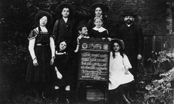
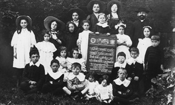
The Tonypandy Hebrew Classes,
September 1909, with Rev. Hermann Abrahams, headmaster
(Photographs courtesy Prof. Peter Abrahams).
|
Other Tonypandy Jewish Institutions &
Organisations
|
-
Tonypandy Hebrew Classes, probably founded at
about the same time as the foundation of the
congregation (see 1909 photographs above).
-
Tonypandy Ladies Benevolent Society, founded by 1910.(xlv)
-
Tonypandy Zionist Society, founded by 1910.(xlvi)
-
Tonypandy Jewish Ladies Society,
founded by 1912.(xlvii)
-
Dr Herman Adler Lodge, Order Achei Brith and Shield of Abraham, Tonypandy,
founded in 1912.(xlviii)
-
Tonypandy Jewish Boys Club,
founded in about 1921.(xlix)
|
|
Tonypandy Jewish Population Data
|
|
Year
|
Number |
Source |
|
1922
|
180 |
The Jewish Year Book 1923 |
|
Click HERE to view Jewish
population figures for the whole of Rhondda Cynon Taf from UK Censuses since 2001.
|
|
Notes & Sources
(↵
returns to text above)
|
|
|
Former Jewish Communities in the county borough of Rhondda Cynon Taf home page
Jewish Congregations in the former county of
Glamorganshire
Jewish Congregations in the former administrative county of Mid Glamorgan
Jewish Congregations in Wales, listed according to current unitary authorities
Jewish Communities & Congregations in Wales home page
Page created: 23 August 2005
Data significantly expanded and notes added: 21 January 2025
Page most recently amended: 14 March 2025
Research and formatting by David Shulman
Explanation of Terms |
About JCR-UK |
JCR-UK home page
Contact JCR-UK Webmaster:
[email protected]


Terms and Conditions, Licenses and Restrictions for the use of this website:
This website is
owned by JewishGen and the Jewish Genealogical Society of Great Britain. All
material found herein is owned by or licensed to us. You may view, download, and
print material from this site only for your own personal use. You may not post
material from this site on another website without our consent. You may not
transmit or distribute material from this website to others. You may not use
this website or information found at this site for any commercial purpose.
Copyright © 2002 - 2025 JCR-UK. All Rights Reserved
|
|


