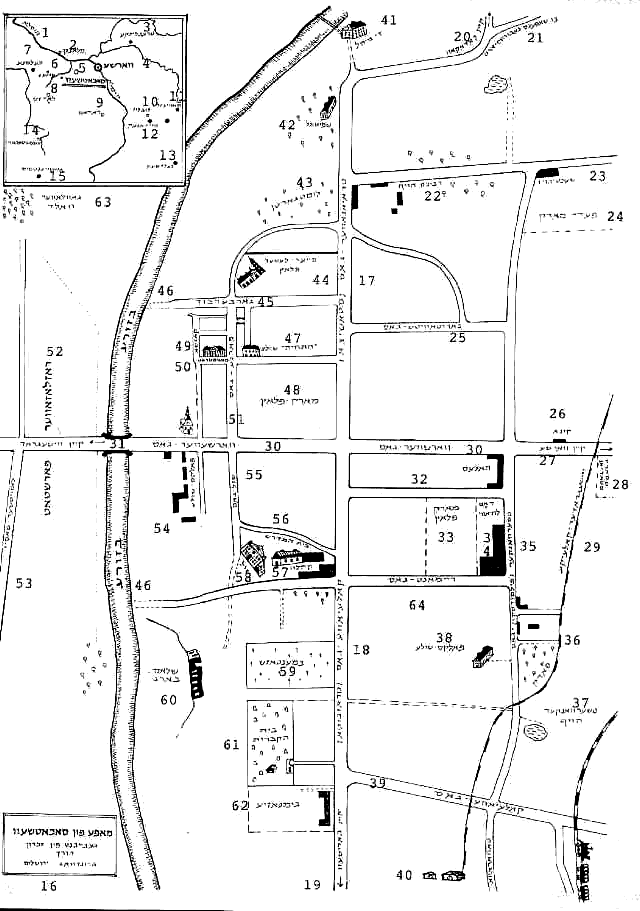
Sochaczew map
Produced from memory by Mr. Yosef Grundwag of Jerusalem (label 16)
Note from translator: I labeled the Hebrew/Yiddish inscriptions from 1-63. I did my best to verify the spelling of cities and towns. For street names, I tried to match Polish spelling, but it is probable that the spelling that I provided is not exact in most cases. I put my own comments in parentheses. In the two cases where street names had parentheses in the original (presumably these are alternative street names), I put them in square brackets so as not to confuse with my own comments.

Small Map in Upper Left Inset
The small map inserted at upper left is a map of Sochaczew in relation to major cities and concentration camps of Poland. Cities are denoted on map by circles, and Concentration Camps by black dots.
- Wysla (River)
- Plock
- Treblinka (Concentration Camp)
- Warsaw
- Sochaczew (underlined)
- Kutna (a city, but noted on map with a black dot, so presumably a Concentration Camp as well, although not a well-known one.)
- Chelmno (Concentration Camp)
- Lodz
- Radom
- Lublin
- Sobibor (Concentration Camp)
- Majdanek (Concentration Camp)
- Belzec (Concentration Camp)
- Czestochowa
- Auschwitz (Osweicim – Concentration Camp)
Main Map
Directions are not labeled, however, since the note (27) at rightmost edge of main street crossing City (Warsawer Street) notes that direction is to Warsaw, and Warsaw is almost directly east of Sochaczew, it can be deduced that the rightmost edge is east, and consequently, the top edge is north. These directions may not be exact, as it is doubtful that the main streets which cross from top-bottom and right-left are exactly north-south and east-west respectively, however from the labels, it is obviously that they are close to that.
- Main label – Map of Sochaczew, produced from memory by Mr. Yosef Grundwag of Jerusalem.
- Trajanower Street [Staszica] – upper segment of main north-south Street
- Kolejova Street [Traugutta] – lower segment of main north-south street
- To Boryszew (village south of Sochaczew)
- To Chodakow (town northeast of Sochaczew)
- To Chopin’s birthplace
- Rabbi’s Hauf (not sure what Hauf means, perhaps a high place)
- Slaughterhouse
- Horse Market
- Narutowicza Street
- Movie theater
- To Warsaw
- Sport stadium
- Wyszogroder train line
- Warsawer Street
- To Wyszogrod (town north of Sochaczew)
- Hales (perhaps from Polish Hala – a hall)
- Market place
- The Ludawi (people’s hall)
- Czerwanker [Pilsudski] Street
- Park
- Czerwanker Hauf
- Folk School
- Kolejova Street
- Towarowa
- The Mill
- Hospital
- Lustgarten
- Pierrer Laszer place
- Garberbuch
- Bzura River
- "Hatechia" school
- Marketplace
- Kazsza
- Magistrate
- Farna Street
- Roszloszower suburb
- Lowiczer highway
- Folk School
- School Street
- The House of Study (Bais Medrash)
- The Community Offices
- The Synagogue
- Cemetery (Christian)
- Schloss Mountain
- Cemetery (Jewish)
- Gymnasia (high school)
- Gowlower Forest
- Remont Street
This material is made available by JewishGen, Inc.
and the Yizkor Book Project for the purpose of
fulfilling our
mission of disseminating information about the Holocaust and
destroyed Jewish communities.
This material may not be copied,
sold or bartered without JewishGen, Inc.'s permission. Rights may be
reserved by the copyright holder.
JewishGen, Inc. makes no representations regarding the accuracy of
the translation. The reader may wish to refer to the original material
for verification.
JewishGen is not responsible for inaccuracies or omissions in the original work and cannot rewrite or edit the text to correct inaccuracies and/or omissions.
Our mission is to produce a translation of the original work and we cannot verify the accuracy of statements or alter facts cited.
 Sochaczew, Poland
 Yizkor Book Project
 JewishGen Home Page
Yizkor Book Director, Lance Ackerfeld
This web page created by Mike Kalt
Copyright © 1999-2025 by JewishGen, Inc.
Updated 25 Oct 2003 by OR


 Sochaczew, Poland
 Yizkor Book Project
 JewishGen Home Page